


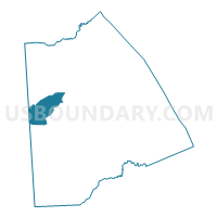
Voting District 06-29, Kent County, Delaware
About
Outline

Summary
| Unique Area Identifier | 550208 |
| Name | Voting District 06-29 |
| County | Kent County |
| State | Delaware |
| Area (square miles) | 23.39 |
| Land Area (square miles) | 23.34 |
| Water Area (square miles) | 0.06 |
| % of Land Area | 99.76 |
| % of Water Area | 0.24 |
| Latitude of the Internal Point | 39.10892960 |
| Longtitude of the Internal Point | -75.69248170 |
Maps

Graphs
Select a template below for downloading or customizing gragh for Voting District 06-29, Kent County, Delaware


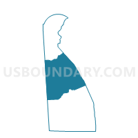
Neighbors
Neighoring Voting District (by Name) Neighboring Voting District on the Map
- Voting District 01-30, Kent County, DE
- Voting District 02-34, Kent County, DE
- Voting District 03-29, Kent County, DE
- Voting District 05-29, Kent County, DE
- Voting District 07-29, Kent County, DE
- Voting District 10-34, Kent County, DE
- Caroline Precinct 01-001, Caroline County, MD
Top 10 Neighboring County Subdivision (by Population) Neighboring County Subdivision on the Map
- Dover CCD, Kent County, DE (77,165)
- Central Kent CCD, Kent County, DE (25,655)
- District 1, Henderson, Caroline County, MD (3,348)
Top 10 Neighboring Place (by Population) Neighboring Place on the Map
Top 10 Neighboring Unified School District (by Population) Neighboring Unified School District on the Map
- Capital School District, DE (54,739)
- Caesar Rodney School District, DE (43,649)
- Caroline County Public Schools, MD (33,066)
Top 10 Neighboring State Legislative District Lower Chamber (by Population) Neighboring State Legislative District Lower Chamber on the Map
- State Legislative District 36, MD (137,167)
- State House District 29, DE (27,839)
- State House District 34, DE (23,514)
- State House District 30, DE (22,102)
Top 10 Neighboring State Legislative District Upper Chamber (by Population) Neighboring State Legislative District Upper Chamber on the Map
- State Senate District 36, MD (137,167)
- State Senate District 15, DE (51,296)
- State Senate District 17, DE (47,176)
Top 10 Neighboring 111th Congressional District (by Population) Neighboring 111th Congressional District on the Map
Top 10 Neighboring Census Tract (by Population) Neighboring Census Tract on the Map
- Census Tract 418.01, Kent County, DE (9,633)
- Census Tract 419, Kent County, DE (5,276)
- Census Tract 418.02, Kent County, DE (5,203)
- Census Tract 9550, Caroline County, MD (3,348)
- Census Tract 420, Kent County, DE (3,173)
Top 10 Neighboring 5-Digit ZIP Code Tabulation Area (by Population) Neighboring 5-Digit ZIP Code Tabulation Area on the Map
- 19904, DE (34,132)
- 19934, DE (12,805)
- 19953, DE (4,386)
- 21649, MD (1,858)
- 21640, MD (1,632)
- 19964, DE (1,340)